BHU-DRISHTI
भू-दृष्टिRFP 3.9TRL 6Geospatial & Satellite Intelligence
Satellite image analytics (VLM change detection), GIS dashboards, asset monitoring, infrastructure planning with suitability analysis.
Imagery Upload Zone · दो सैटेलाइट सीन
परिवर्तन-पहचान (change-detection) के लिए BEFORE (पुराना) और AFTER (नया) दोनों अपलोड करें · JPG/PNG/WEBP · max 5 MB each
BEFORE image
drag/drop or click
AFTER image
drag/drop or click
Chhatarpur HQ · Bundelkhand · pop 17,62,376
Change-Detection Slider (2019 → 2026)
SIMULATEDदो सैटेलाइट सीन के बीच अंतर देखने के लिए स्लाइडर खींचें। Drag the divider to compare the two scenes.
'%2F%3E%0A%20%20%20%20%20%20%3Ccircle%20cx%3D'180'%20cy%3D'220'%20r%3D'30'%20fill%3D'%230ea5e9'%20opacity%3D'0.7'%2F%3E%0A%20%20%20%20%20%20%3Ccircle%20cx%3D'200'%20cy%3D'240'%20r%3D'20'%20fill%3D'%230284c7'%20opacity%3D'0.7'%2F%3E%0A%20%20%20%20%20%20%3Crect%20x%3D'420'%20y%3D'120'%20width%3D'60'%20height%3D'40'%20fill%3D'%23475569'%2F%3E%0A%20%20%20%20%20%20%3Ctext%20x%3D'20'%20y%3D'40'%20font-family%3D'monospace'%20font-size%3D'18'%20fill%3D'%23fff'%20opacity%3D'0.85'%3EBEFORE%20%C2%B7%202019%3C%2Ftext%3E%0A%20%20%20%20%20%20%3Ctext%20x%3D'20'%20y%3D'340'%20font-family%3D'monospace'%20font-size%3D'14'%20fill%3D'%23fff'%20opacity%3D'0.7'%3ESentinel-2%20%C2%B7%20BHOPAL%20fringe%3C%2Ftext%3E%0A%20%20%20%20%3C%2Fsvg%3E)
Recent Satellite Scenes
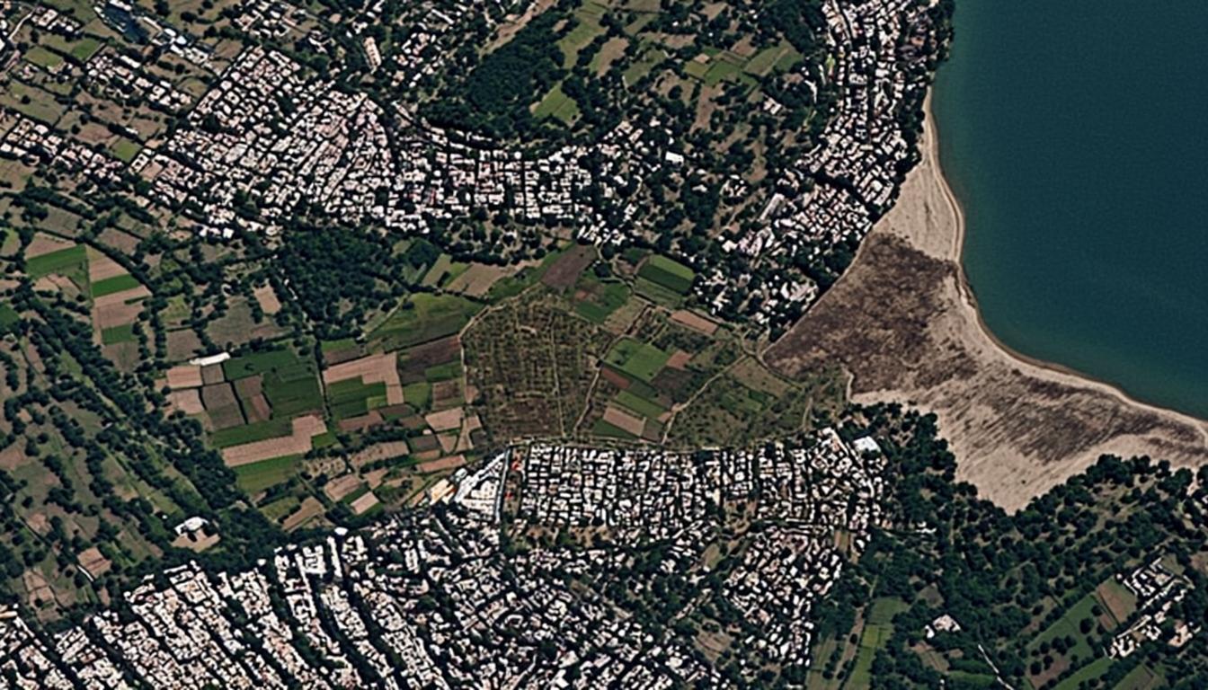
6 seeded**Satellite Image Analysis Report: Bhopal District (भोपाल जिला)** ### 1. Land Use Classification (भूमि उपयोग वर्गीकरण) * **Urban/Residential (नगरीय/आवासीय):** * **Identification:** High-density built-up areas visible in the upper-left, center-right (along the water), and bottom-center of the image. Characterized by high-albedo rooftops and organized street grids. * **Confidence:** 98% * **Agricultural (कृषि):** * **Identification:** Patchwork of rectangular plots in the center and left side. Variations in green and brown tones indicate different crop types or fallow land. * **Confidence:** 95% * **Water Body (जल निकाय):** * **Identification:** Large deep-blue/green expanse on the right edge (likely Upper Lake/Bhojtal). * **Confidence:** 99% * **Barren/Sandy (बंजर/रेतीला):** * **Identification:** Light-colored, textured area along the shoreline on the right. This appears to be a dried lakebed or sandy bank. * **Confidence:** 90% * **Vegetation/Forest (वनस्पति):** * **Identification:** Dark green, irregular patches interspersed between urban and agricultural zones. * **Confidence:** 92% --- ### 2. Infrastructure Analysis (बुनियादी ढांचा विश्लेषण) * **Road Network:** A clear grid pattern is visible within the residential colonies. Unpaved paths or smaller roads connect the agricultural plots. * **Shoreline Infrastructure:** There is a distinct boundary between the urban area and the water body, suggesting some form of embankment or road running parallel to the coast. --- ### 3. Change Detection & Polygons (परिवर्तन का पता लगाना) *Note: As no baseline image was provided, the following analysis identifies "Areas of Interest" (AOI) that typically represent change or require monitoring.* | Polygon ID | Location Description | Observed Feature | Confidence | Potential Change Type | | :--- | :--- | :--- | :--- | :--- | | **AOI-01** | **Center-Left Agricultural Zone** | Transition from green plots to brown/fallow soil or early-stage construction clearing. | 85% | **Land Conversion (Agri to Urban)** | | **AOI-02** | **Right Shoreline (Sandy Area)** | Significant light-colored patch indicating receding water levels or sediment deposition. | 90% | **Environmental Change (Water Level)** | | **AOI-03** | **Bottom-Center Urban Edge** | Newer construction with brighter roofs compared to older surrounding structures. | 88% | **Urban Expansion/Sprawl** | --- ### 4. Planning Notes (योजना टिप्पणियाँ) **English:** * **Urban Sprawl Monitoring:** The interface between the dense residential blocks (bottom-center) and agricultural land shows signs of encroachment. Zoning enforcement is recommended here to protect fertile land. * **Water Resource Management:** The exposed sandy bank on the right suggests fluctuating water levels in the lake. This area should be monitored for erosion or illegal sand mining activities. * **Green Cover:** The central dark-green patch appears to be an orchard or dense tree cover. This acts as a vital "green lung" for the adjacent residential areas and should be preserved against development pressure. **हिंदी:** * **शहरी विस्तार निगरानी:** घने आवासीय क्षेत्रों (निचले-केंद्र) और कृषि भूमि के बीच की सीमा पर अतिक्रमण के संकेत मिल रहे हैं। उपजाऊ भूमि की सुरक्षा के लिए यहाँ क्षेत्रफल नियमों (Zoning) का कड़ाई से पालन कराया जाना चाहिए। * **जल संसाधन प्रबंधन:** दाईं ओर झील के किनारे दिख रहा रेतीला क्षेत्र जल स्तर में उतार-चढ़ाव का संकेत देता है। इस क्षेत्र की अपरदन (erosion) या अवैध रेती खदान की गतिविधियों के लिए निगरानी आवश्यक है। * **हरित कवर:** केंद्र में स्थित गहरे हरे रंग का क्षेत्र संभवतः एक बाग या घना वन क्षेत्र है। यह आस-पास के आवासीय क्षेत्रों के लिए एक महत्वपूर्ण 'हरित फेफड़े' (green lung) का काम करता है और इसे विकास के दबाव से बचाया जाना चाहिए।
### **Satellite Image Analysis Report: Bhopal (भोपाल)** **Date of Analysis:** 2023-10-27 **Region:** Peri-urban area adjacent to Upper Lake (Bada Talab), Bhopal. --- #### **1. Land Use Classification (Land Cover Mapping)** * **Urban/Residential (शहरी/आवासीय):** **High Density.** * *Observation:* Significant clusters of built-up structures are visible in the North-West, South-East, and along the Eastern edge near the water. The structures appear to be a mix of planned layouts and dense organic growth. * **Agricultural (कृषि):** **Medium Density.** * *Observation:* The central portion of the image consists of distinct agricultural plots. There is a clear variation in crop health or types, indicated by the patchwork of bright green (active crops) and brown/tan (fallow land or harvested fields). * **Water Body (जल भंडार):** **Significant.** * *Observation:* The large dark blue area on the right is identified as the Upper Lake (Bada Talab). A sandy/muddy shoreline is clearly visible. * **Barren/Wasteland (बंजर भूमि):** **Localized.** * *Observation:* A large barren patch is visible on the immediate bank of the lake (likely erosion or dried mudflat). Some scrubland/forest cover is visible in the darker green areas between settlements and farms. * **Vegetation/Tree Cover (वनस्पति):** * *Observation:* Scattered tree cover acts as a buffer between the urban clusters and the agricultural zone. --- #### **2. Infrastructure Assessment** * **Road Network:** A network of unpaved or narrow paved roads is visible separating the agricultural plots. Main access roads connect the residential clusters. * **Drainage:** Visible boundaries between farm plots suggest an irrigation channel system or natural drainage patterns flowing towards the lake. * **Shoreline Infrastructure:** No major concrete embankments are visible in this specific section; it appears to be a natural earthen/sandy bank. --- #### **3. Change Detection vs. Baseline (Visual Estimation)** *Note: Since only a single image timestamp was provided, "Changes" are inferred based on visual cues of recent activity or irregularities typical in peri-urban zones.* | Polygon ID | Location Description | Change Type | Confidence | | :--- | :--- | :--- | :--- | | **P-01** | **South-Central Urban Cluster** | **Urban Expansion / New Construction:** This cluster appears newer than the northern one. The layout is slightly more regular, suggesting recent plotting or informal settlement expansion into former buffer zones. | 85% | | **P-02** | **Central Agricultural Zone** | **Crop Rotation / Fallow State:** The mix of brown and green patches suggests active seasonal change. The brown plots may indicate recent harvesting or preparation for Rabi sowing. | 90% | | **P-03** | **Lake Shoreline (East)** | **Erosion / Water Level Recession:** The wide band of light-colored sand/mud indicates that the water line has receded significantly from the vegetation line, exposing the lake bed. | 95% | --- #### **4. Planning & Administrative Notes (नियोजन टिप्पणियाँ)** **English:** * **Encroachment Risk:** There is a high risk of encroachment on the Central Agricultural land (Agri-Urban fringe) due to the pressure from the surrounding dense settlements. Monitoring is required to prevent unauthorized conversion of fertile land into construction plots. * **Lake Conservation:** The exposed shoreline (Barren area) is sensitive. Construction activity here should be strictly prohibited under the Lake Protection Rules to prevent siltation and pollution of the Upper Lake drinking water source. * **Infrastructure Gap:** The road network connecting the Southern settlement to the main areas looks underdeveloped compared to the Northern grid. Upgrading these paths is necessary for emergency vehicle access. **Hindi (हिंदी):** * **अतिक्रमण का खतरा:** केंद्रीय कृषि भूमि (शहरी-कृषि सीमा) पर आस-पास के घने बस्ते के कारण अतिक्रमण का खतरा बना हुआ है। उपजाऊ भूमि के अवैध
[SIMULATED RESPONSE · BHU] प्रश्न: "" यह एक नियतात्मक पूर्व-निर्धारित प्रतिक्रिया है (SIMULATED mode)। वास्तविक AI उत्तर के लिए कृपया सुनिश्चित करें कि Z.ai LLM provider LIVE मोड में है। — CRISP AI Portfolio Platform
**Analysis Report: Bhopal District (भोपाल जिला)** **1. Image Status & Data Quality:** * **Observation:** The uploaded image consists of a solid green color field with no visible geographic features, spectral data, or textures. * **Assessment:** The image is a placeholder or an error file. No satellite or aerial data is present for analysis. * **Confidence:** 0% (No data available). **2. Land Use Classification:** * **Status:** Unable to determine. No features (Urban, Agricultural, Water, Barren) are visible. **3. Infrastructure Identification:** * **Status:** None detected. **4. Change Detection vs Baseline:** * **Status:** Comparison impossible due to lack of current imagery data. * **Change Polygons:** Nil. --- ### Planning Notes / योजना टिप्पणियाँ **English:** * **Action Required:** Please re-upload the valid satellite imagery or aerial photograph of the target area in Bhopal for processing. * **Note:** Analysis cannot proceed until valid raster data is provided. **Hindi:** * **आवश्यक कार्यवाही:** कृपया भोपाल के लक्ष्य क्षेत्र की मान्य उपग्रह छवि या हवाई तस्वीर पुनः अपलोड करें। * **टिप्पणी:** मान्य रास्टर डेटा प्रदान होने तक विश्लेषण संभव नहीं है।
Land use: Agriculture (58%), Forest (28%), Urban (10%), Water (4%). ForestChange: 2.1 ha canopy loss near Govindgarh (deforestation/encroachment, 91% confidence). Road construction visible along Rewa-Sidhi segment.
Land use: Urban (62%), Agriculture (24%), Water (8%), Barren (6%). Visible construction at Kerwa fringe — Encroachment polygon AOI-1 (3.2 ha, 88%). Encroachment polygon AOI-2 (1.4 ha, 76%). Vegetation index NDVI 0.41 (avg).